ARCHIVED – Process Update for TGS NOPEC Geophysical Company ASA (TGS), Petroleum GeoServices (PGS) and Multi Klient Invest (MKI) NorthEastern Canada 2D Seismic Survey (the Project)
This page has been archived on the Web
Information identified as archived is provided for reference, research or recordkeeping purposes. It is not subject to the Government of Canada Web Standards and has not been altered or updated since it was archived. Please contact us to request a format other than those available.
File OF-EP-GeoOp-M711-5554587 02
22 March 2013
To: All Interested Parties
Process Update for TGS NOPEC Geophysical Company ASA (TGS), Petroleum GeoServices (PGS) and Multi Klient Invest (MKI) NorthEastern Canada 2D Seismic Survey (the Project)
TGS, PGS and MKI propose to conduct an offshore marine seismic survey in Baffin Bay/Davis Strait. The proposed Project is expected to be carried out over five years during the open water season beginning in 2013. TGS, PGS and MKI have applied to the National Energy Board (NEB) for a geophysical operations authorization (GOA) for the Project under the Canada Oil and Gas Operation Act (COGOA).
This letter updates the process information dated 13 July 2011 and 11 October 2011. In these past letters, the NEB committed to provide a draft environmental screening report for public comment under the Canadian Environmental Assessment Act. That act has since been repealed however and replaced with the Canadian Environmental Assessment Act, 2012 (CEA Act 2012). Although the Project is not subject to the CEA Act 2012, the NEB is continuing its environmental assessment of the Project under the COGOA and is releasing a discussion paper. The discussion paper is appended and provides information regarding the Project and will guide discussions at community meetings where oral comments will be heard.
The public meetings will be held from 7:00 to 9:00 pm in the following communities:
- Pond Inlet – Monday 29 April 2013 at the Pond Inlet Community Hall
- Clyde River – Tuesday 30 April 2013 at the Tuqqayaq Community Hall
- Qikiqtarjuaq – Wednesday 1 May 2013 at the Avviujaq Gymnasium
- Iqaluit – Thursday 2 May 2013 at the Anglican Parish Hall
Representatives from the company will be present at the public meetings to present information about the Project and answer questions regarding the Project.
The NEB will also be accepting written comments from the public on issues relevant to this Project, particularly the potential environmental effects and mitigation measures outlined in the discussion paper. Written comments must be submitted by 3 May 2013 by Email at ExproEA@cer-rec.gc.ca or by mailing them to the National Energy Board, 444 Seventh Avenue SW, Calgary Alberta T2P 0X8, Attention: Team Leader Conservation of Resources.
Under section 15 of the National Energy Board Act, the NEB authorized Board Member David Hamilton to report and make recommendations on the Project application. Written comments from the public and information gathered from community meetings will inform Mr. Hamilton’s report and recommendations to the NEB. The NEB will then decide whether to approve or deny the Project application.
If you have any questions about the above information, please contact the Regulatory Officer, Danielle Comte at 403-299-2731 or toll free at 1-800-899-1265.
Yours truly,
Sheri Young Secretary of the Board
Attachment
Discussion Paper for Public Comments
on the Review of the Application for the
Proposed NORTHEASTERN CANADA 2D SEISMIC SURVEY
(Baffin Bay/Davis Strait)
TGS NOPEC Geophysical ASA (TGS), Petroleum GeoServices (PGS) and Multi Klient Invest AS (MKI) NorthEastern Canada 2D Seismic Survey Application
1. INTRODUCTION
PGS and TGS want to conduct a seismic survey in Baffin Bay and Davis Strait each open water season (July-Nov) for up to five years beginning in 2013 (the Project). MKI is a wholly-owned subsidiary of PGS and would be the company that operates the Project if it is approved. TGS, PGS and MKI have applied to the National Energy Board (NEB) for a geophysical operations authorization (GOA) for the Project under the Canada Oil and Gas Operation Act (COGOA).
This paper provides information regarding the Project to facilitate public comments on it. Interested parties are invited to submit written comments to the Board and/or provide oral comments at community meetings. Written comments must be submitted by 3 May 2013 by Email at ExproEA@cer-rec.gc.ca or by mail to the National Energy Board, 444 Seventh Avenue S.W., Calgary, Alberta, T2P 0X8, Attention: Team Leader, Conservation of Resources.
You can access documents related to the environmental assessment of the Project on the Public Registry.
2. PROJECT BACKGROUND
2.1 Project Description
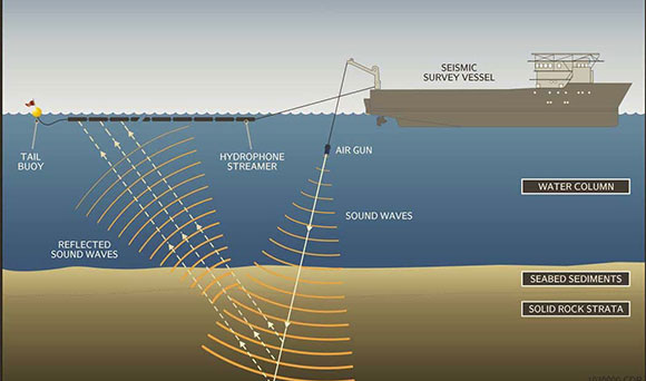
As shown in the diagram below (Figure 1), the survey would involve a seismic survey ship travelling back and forth across the area shown in the map below (Map 1) towing an array of airguns that produce pulses of sound waves under the water. The sound waves pass through the water and into the rock below the seabed. The reflected sound waves from the rock layers are detected and recorded by listening devices on the streamers called hydrophones, which are also towed by the seismic survey ship. The loudness of the airguns is estimated to be 230 decibels at a distance of 1 meter away, and will be repeated every 13 to 15 seconds, 24 hours a day while operating. See Appendix 1 for further details.
Figure 1: Seismic Survey
2.2 Location
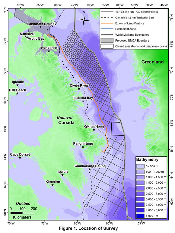
The proposed Project will occur seaward of Canada’s 12 nautical mile boundary and outside of the Land Fast Ice Zone to the Greenland border (See Map 1 below). The northern extent of the seismic survey is approximately 180 km from the mouth of the proposed Lancaster Sound National Marine Conservation Area extending south to the 60 N parallel. The majority of the Project will be conducted in deep waters (ranging from 360 m to 3,660 m), covering an area of approximately 16,173 linear kilometres.
The Nunavut Planning Commission determined on 19 January 2011 that the proposed Project falls outside the boundaries of the North Baffin Regional Land Use Plan and that no conformity review with the approved plan is required; consequently the Project was not forwarded to the Nunavut Impact Review Board for screening.
Map 1: Project Location
2.3 Project Purpose
The company has proposed the Project to gain a better understanding of the offshore geology in Baffin Bay and Davis Strait and determine the regional extent of geological formations. The company believes a high-quality modern regional data set is required to compliment historic data. The results of the survey may be used to inform new exploration activities.
3. COMMENTS FROM THE PUBLIC
The company has been discussing the Project with the communities of Iqaluit, Clyde River, Pond Inlet, Qikiqtarjuaq, Pangnirtung, and Kimmirut from January 2011 to the present day. The NEB received letters of comment from the following organizations: the Qikiqtani Inuit Association, Environment Canada, the Arctic Fisheries Alliance, the Baffin Fisheries Coalition, Fisheries and Oceans Canada and the Government of Nunavut. Letters were also received from Shari Gearheard on behalf of Clyde River residents. Issues and concerns raised related to:
- Environmental impacts on marine mammals (including whale migration routes, calving and feeding), fish and invertebrates;
- Effects on traditional and commercial harvesting, including compensation for losses;
- Adequacy of mitigation of potential harm to marine mammals including ramp up times, low visibility procedures and Marine Mammal Observers (MMO);
- Need for discussions with communities and use of Inuit Qaujimajatuqangit (Inuit traditional knowledge);
- Employment opportunities, training and benefits including plans for MMOs;
- The use of seismic data, and future exploration plans and the impacts of offshore drilling;
- The absence of a regional environmental assessment or wildlife management planning efforts; and
- The management of waste, wastewater, and ballast water.
The NEB will take these issues into consideration in its environmental assessment and decision-making, to the extent that they are relevant to the Project and within the NEB’s regulatory mandate under COGOA.
4. POTENTIAL ENVIRONMENTAL EFFECTS
The NEB is conducting an environmental assessment as part of its assessment of the GOA application for the Project. A number of potential environmental effects from the Project have been identified.
4.1 Effects of Seismic Operations on Marine Mammals
The noise generated by the air guns during seismic operations has the potential to result in the following effects:
- Long term and short term hearing damage;
- Masking of communication as a result of overlapping sound of the air guns and whale calls; and
- Changes in behavior or movement patterns such as avoidance.
4.2 Other Potential Environmental Effects of Seismic Operations
- Disturbance to fish including localized avoidance.
- Changes in commercial and traditional harvesting.
- Disturbance to birds and/or attraction to onboard lights.
- Disturbance to, damage, and or mortality of marine invertebrates.
- Decrease in local air and water quality due to ineffective management of ship board waste, ballast and bilge water and spills.
- Damage to water quality and wildlife due to accidents and malfunctions such as spills.
5. MITIGATION MEASURES PROPOSED
The company has proposed various measures to mitigate the impacts of potential environmental effects from the Project.
5.1 Mitigation Measures for the Effects of Seismic Operations on Marine Mammals, Fish and Invertebrates
- As described in the ‘Statement of Canadian Practice with respect to the Mitigation of Seismic Noise in the Marine Environment’ (see Appendix 2 for the complete document):
- Planning a seismic survey to avoid significant effects to a population or individuals of a species at risk, such as avoiding known feeding areas.
- following a safety zone and start-up procedure including:
- a MMO continuously observing the safety zone (i.e. a 500 m area surrounding the seismic vessel) for 30 minutes (minimum) prior to the start-up of the air gun source array and maintaining a watch of the safety zone while the air gun source array is under power;
- a gradual ramp-up of the air gun source over a minimum of 20 minutes every time the air guns have been shut down for more than 30 minutes; and
- the air gun source must be immediately shut down if a marine mammal is observed in the safety zone.
- Altering vessel speed/course providing it will not compromise operational safety requirements.
- Powering down the airguns during transit from one seismic line to another.
- All guns will be turned off except for one gun, which will function as a signal intended to alert mammals of the presence of the vessel.
- Using Passive Acoustic Monitoring on a trial basis to monitor the presence of whales.
5.2. Mitigation Measures for Potential Changes to Traditional and Commercial Harvesting
- The seismic activity will not take place near any native harvest area.
- The Community Liaison Officer will maintain communication with the company to provide updates to the Hamlet Council, Hunters and Trappers Organizations and the community.
- A Fisheries Liaison Officer will maintain communication with all fishing vessels near the vicinity of the seismic survey.
- The seismic vessel will avoid active fixed gear fishing areas.
5.3 Mitigation Measures with Respect to Seabirds
- A ramp-up of the air gun source over a minimum of 20 minutes every time the air guns have been shut down for more than 30 minutes.
- The company will follow mitigation designed to ensure stranded birds are safely returned to their natural habitat by following handling procedures designed by the Canadian Wildlife Service.
5.4 Mitigation Measures for Potential Environmental Effects to Air and Water Quality and Effects related to Accidents and Malfunctions
The company is required to obtain an Arctic Waters Pollution Prevention Certificate and operate in accordance with the Arctic Waters Pollution Prevention Act. The company has prepared the following plans with respect to vessel operations:
- Ballast Water Management Plan;
- Waste Management Plan; and
- Ship Oil Pollution Emergency Plan.
6. NEXT STEPS
The NEB is interested in hearing your comments on issues relevant to this Project, particularly the potential environmental effects and mitigation measures outlined in this paper. For example, are there additional impacts not already identified, or is there additional mitigation you can suggest? Comments from the public must be submitted in writing by 3 May 2013 by Email at ExproEA@cer-rec.gc.ca or by mail to the National Energy Board, 444 Seventh Avenue SW, Calgary Alberta T2P 0X8, Attention: Team Leader Conservation of Resources.
This paper will also guide discussions at community meetings where oral comments will be heard. Community meetings will be conducted in April and May 2013 in Iqaluit, Pond Inlet, Clyde River and Qikitarjuaq. Please contact the Regulatory Officer, Danielle Comte at 403-299-2731 or toll free at 1-800-899-1265 for further information regarding the community meetings.
Under section 15 of the National Energy Board Act, the NEB authorized Board Member David Hamilton to report and make recommendations to the NEB about the Project application. Written comments from the public and information gathered from community meetings will inform Mr. Hamilton’s report and recommendations to the NEB. The NEB will then decide whether to approve or deny the Project application.
We look forward to your participation.
7. Glossary of Terms
Airgun: An airgun is a specialized sound source that creates underwater sound by releasing a burst of compressed air into the water at great speed. During seismic operations airguns are towed in arrays of several airguns. The airguns are fired simultaneously to generate enough sound for geophysical measurements.
Ballast Water: Refers to water held in tanks on ships to increase stability and maneuverability of the ship during transit. Ballast water may be taken on or released depending on the amount or weight of the ship’s cargo or during changing sea conditions.
Bilge water: This is water that collects in the lowest point of a ships hull. Most bilge systems are designed to keep the decks clear of accumulated water during wet weather.
Decibel (dB): A decibel is used to quantify sound levels and is a logarithmic scale rather than a linear scale. The human and marine mammal sense of hearing is also logarithmic so decibels are used for sound measurement. For example 0-20 dB is very faint and 90-100 dB is very loud.
Gravity Meter: A device that measures changes in the local gravitational field of the earth. Changes in the gravitational field may be caused by geologic structures.
Hydrophone: A device used to record underwater sound including seismic data.
Masking: When a sound is masked it is not possible to hear it because another louder sound is covering up the particular sound. For example, it is difficult to hear someone talking when you are on a snowmobile because the engine noise masks the speaker’s voice.
National Marine Conservation Area: Marine areas managed for sustainable use and containing zones of high protection. They include the seabed, the water above it and any species which occur there. They may also take in wetlands, estuaries, islands and other coastal areas. They are designated by Parks Canada.
Streamer: Solid cables that are towed 5-10 m below the surface of the water and contain the hydrophones.
Appendix 1 Project Description
| Description of Physical Activities |
|---|
Seismic Data Acquisition:
|
Seismic and Support Vessel Travel and Operations:
|
Non-Seismic Data Collection Activities:
|
Appendix 2
Statement of Canadian Practice with respect to the Mitigation of Seismic Sound in the Marine Environment
Context
The Statement of Canadian Practice with respect to the Mitigation of Seismic Sound in the Marine Environment specifies the mitigation requirements that must be met during the planning and conduct of marine seismic surveys, in order to minimize impacts on life in the oceans. These requirements are set out as minimum standards, which will apply in all non-ice covered marine waters in Canada. The Statement complements existing environmental assessment processes, including those set out in settled land claims. The current regulatory system will continue to address protection of the health and safety of offshore workers and ensure that seismic activities are respectful of interactions with other ocean users.
Definitions
Cetacean: means a whale, dolphin or porpoise.
Critical habitat: means the habitat that is necessary for the survival or recovery of a listed wildlife species and that is identified as the species' critical habitat in the recovery strategy or in an action plan for the species.
Marine Mammal Observer: means an individual trained to identity different species of marine mammals and turtles that may reasonably be expected to be present in the area where the seismic survey will take place.
Marine mammals: means all cetaceans and pinnipeds.
Passive Acoustic Monitoring: means a technology that may be used to detect the subsea presence of vocalizing cetaceans.
Pinniped: means a seal, sea lion or walrus.
Ramp-up: means the gradual increase in emitted sound levels from a seismic air source array by systematically turning on the full complement of an array’s air sources over a period of time.
Seismic air source: means an air source that is used to generate acoustic waves in a seismic survey.
Seismic air source array(s): means one or a series of devices designed to release compressed air into the water column in order to create an acoustical energy pulse to penetrate the seafloor.
Seismic survey: means a geophysical operation that uses a seismic air source to generate acoustic waves that propagate through the earth, are reflected from or refracted along subsurface layers of the earth, and are subsequently recorded.
“Statement”: means the Statement of Canadian Practice for the Mitigation of Seismic Sound in the Marine Environment.
Whale: means a cetacean that is not a dolphin or porpoise.
Application
- Unless otherwise provided, the mitigation measures set out in this Statement apply to all seismic surveys planned to be conducted in Canadian marine waters and which propose to use an air source array(s).
- The mitigation measures set out in this Statement do not apply to seismic surveys conducted:
- on ice-covered marine waters; or
- in lakes or the non-estuarine portions of rivers.
Planning Seismic Surveys
Mitigation Measures
- Each seismic survey must be planned to
- use the minimum amount of energy necessary to achieve operational objectives;
- minimize the proportion of the energy that propagates horizontally; and
- minimize the amount of energy at frequencies above those necessary for the purpose of the survey.
- All seismic surveys must be planned to avoid:
- a significant adverse effect for an individual marine mammal or sea turtle of a species listed as endangered or threatened on Schedule 1 of the Species at Risk Act; and
- a significant adverse population-level effect for any other marine species.
- Each seismic survey must be planned to avoid:
- displacing an individual marine mammal or sea turtle of a species listed as endangered or threatened on Schedule 1 of the Species at Risk Act from breeding, feeding or nursing;
- diverting an individual migrating marine mammal or sea turtle of a species listed as endangered or threatened on Schedule 1 of the Species at Risk Act from a known migration route or corridor;
- dispersing aggregations of spawning fish from a known spawning area;
- displacing a group of breeding, feeding or nursing marine mammals, if it is known there are no alternate areas available to those marine mammals for those activities, or that if by using those alternate areas, those marine mammals would incur significant adverse effects; and
- diverting aggregations of fish or groups of marine mammals from known migration routes or corridors if it is known there are no alternate migration routes or corridors, or that if by using those alternate migration routes or corridors, the group of marine mammals or aggregations of fish would incur significant adverse effects.
Safety Zone and Start-up
Mitigation Measures
- Each seismic survey must:
- establish a safety zone which is a circle with a radius of at least 500 metres as measured from the centre of the air source array(s); and
- for all times the safety zone is visible,
- a qualified Marine Mammal Observer must continuously observe the safety zone for a minimum period of 30 minutes prior to the start up of the air source array(s), and
- maintain a regular watch of the safety zone at all other times if the proposed seismic survey is of a power that it would meet a threshold requirement for an assessment under the Canadian Environmental Assessment Act, regardless of whether the Act applies.
- If the full extent of the safety zone is visible, before starting or restarting an air source array(s) after they have been shut-down for more than 30 minutes, the following conditions and processes apply:
- none of the following have been observed by the Marine Mammal Observer within the safety zone for at least 30 minutes:
- a cetacean or sea turtle,
- a marine mammal listed as endangered or threatened on Schedule 1 of the Species at Risk Act, or
- based on the considerations set out in sub-section 4(b), any other marine mammal that has been identified in an environmental assessment process as a species for which there could be significant adverse effects; and
- a gradual ramp-up of the air source array(s) over a minimum of a 20 minute period beginning with the activation of a single source element of the air source array(s), preferably the smallest source element in terms of energy output and a gradual activation of additional source elements of the air source array(s) until the operating level is obtained.
- none of the following have been observed by the Marine Mammal Observer within the safety zone for at least 30 minutes:
Shut-down of Air Source Array(s)
Mitigation Measures
- The air source array(s) must be shut down immediately if any of the following is observed by the Marine Mammal Observer in the safety zone:
- a marine mammal or sea turtle listed as endangered or threatened on Schedule 1 of the Species at Risk Act; or
- based on the considerations set out in sub-section 4(b), any other marine mammal or sea turtle that has been identified in an environmental assessment process as a species for which there could be significant adverse effects.
Line Changes and Maintenance Shut-downs
Mitigation Measures
- When seismic surveying (data collection) ceases during line changes, for maintenance or for other operational reasons, the air source array(s) must be:
- shut down completely; or
- reduced to a single source element.
- If the air source array(s) is reduced to a single source element as per subsection 9(b), then:
- visual monitoring of the safety zone as set out in section 6 and shut-down requirements as set out in section 8 must be maintained; but
- ramp-up procedures as set out in section 7 will not be required when seismic surveying resumes.
Operations in Low Visibility
Mitigation Measures
- Under the conditions set out in this section, cetacean detection technology, such as Passive Acoustic Monitoring, must be used prior to ramp-up for the same time period as for visual monitoring set out in section 6. Those conditions are as follows:
- the full extent of the safety zone is not visible; and
- the seismic survey is in an area that
- has been identified as critical habitat for a vocalizing cetacean listed as endangered or threatened on Schedule 1 of the Species at Risk Act, or
- in keeping with the considerations set out in sub-section 4(b), has been identified through an environmental assessment process as an area where a vocalising cetacean is expected to be encountered if that vocalizing cetacean has been identified through the environmental assessment process as a species for which there could be significant adverse effects.
- If Passive Acoustic Monitoring or similar cetacean detection technology is used in accordance with the provision of section 11, unless the species can be identified by vocal signature or other recognition criteria:
- all non-identified cetacean vocalizations must be assumed to be those of whales named in sections 8(a) or (b); and
- unless it can be determined that the cetacean(s) is outside the safety zone, the ramp-up must not commence until non-identified cetacean vocalizations have not been detected for a period of at least 30 minutes.
Additional Mitigative Measures and Modifications
Mitigation Measures
- Persons wishing to conduct seismic surveys in Canadian marine waters may be required to put in place additional or modified environmental mitigation measures, including modifications to the area of the safety zone and/or other measures as identified in the environmental assessment of the project to address:
- the potential for chronic or cumulative adverse environmental effects of
- multiple air source arrays (e.g., two vessels on one project; multiple projects), or
- seismic surveys being carried out in combination with other activities adverse to marine environmental quality in the area affected by the proposed program or programs;
- variations in sound propagation levels within the water column, including factors such as seabed, geomorphologic, and oceanographic characteristics that affect sound propagation;
- sound levels from air source array(s) that are significantly lower or higher than average; and
- species identified in an environmental assessment process for which there is concern, including those described in sub-section 4b).
- the potential for chronic or cumulative adverse environmental effects of
- Variations to some or all of the measures set out in this Statement may be allowed provided the alternate mitigation or precautionary measures will achieve an equivalent or greater level of environmental protection to address the matters outlined in sections 6 through 13 inclusive. Where alternative methods or technologies are proposed, they should be evaluated as part of the environmental assessment of the project.
- Where a single source element is used and the ramping up from an individual air source element to multiple elements is not applicable, the sound should still be introduced gradually whenever technically feasible.
Source: Fisheries and Oceans Website
- Date modified: