Offshore Physical Environmental Guidelines
3.0 Program Description
3.0 Program Description
3.1 Observations
3.2 Meteorology, Oceanography and Ice Observing
3.2.1 Parameters to be Observed
3.2.2 Oceanographic Parameters to be Observed
3.2.3 Ice Management Parameters to be Observed
3.3 Collection Specifications
3.4 Real-Time Meteorological, Oceanographic and Ice Reporting
3.4.1 Marine Weather Reporting
3.4.2 Aviation Reporting
3.4.3 Metadata Reporting
3.4.4 Oceanographic Data Reporting
3.4.5 Ice Reporting Procedures
3.5 Equipment Requirements
3.5.1 Selection and Installation of Monitoring Equipment
3.5.2 Instruments
3.5.3 Monitoring Equipment Specifications
3.5.4 Integrated Reporting Equipment
3.5.5 Equipment Approval Process
3.5.6 New Technologies
3.0 Program Description
3.1 Observations
The Operator is required, pursuant to the Regulations, to take meteorological, oceanographic and ice measurements during drilling and production programs on Frontier Lands.
Unless otherwise agreed to in writing by the Regulator, observations should be taken in accordance with these PEGs, and the standards and procedures referenced herein. The Regulator, after consultation with the Operator and the appropriate government agencies, may exempt the Operator from those standards and procedures deemed not to be applicable to specific offshore operations.
The following environmental parameters should be observed and recorded daily:
- The presence of any ice floes or icebergs and their movement;
- At least once every three hours:
- Wind direction and speed,
- Wave height period and direction,
- Swell direction, height and period,
- Current direction and speed
- Barometric pressure,
- Characteristic of pressure tendency,
- Air temperature,
- Sea surface temperature,
- Visibility,
- Wet bulb/dew point,
- Present weather,
- Cloud type, height and amount;
- The pitch, roll and heave of floating installations;
- Ocean temperature and salinity at the current measurement depths and times, when feasible.
Vessel response information about the pitch, roll and heave of the helideck is required to land a helicopter on a floating installation. The above list is further specified in this document.
3.2 Meteorology, Oceanography and Ice Observing
The following subsections outline the main features of offshore aviation and marine weather observing.
The Operator should be prepared to measure and make available additional oceanographic data as required by the Regulator to support marine safety and environmental protection (e.g. spill countermeasures or fate & effects assessments).
The Operator should ensure that oceanographic equipment that may be used for emergency events is tested periodically to ensure that it would be available for use and that it is operating within established parameters.
3.2.1 Parameters to be Observed
Parameters to be observed and/or reported are listed in Table 3-1.
Table 3 1 - Aviation and Marine Observing and Reporting Parameters
| Parameter | Reported | Notes |
|---|---|---|
| Wind direction | Aviation / Marine | From which the wind is blowing, clockwise from true north in degrees (meteorological convention). 10 minute average for marine, 2 minute average for aviation |
| Wind speed | Aviation / Marine | 10 minute average for marine, 2 minute average for aviation Gusts and squalls are reported for aviation but not for marine. |
| Mean sea level pressure | Aviation / Marine | Derived quantity |
| Pressure tendency | Aviation / Marine | 3-hour pressure difference |
| Pressure tendency characteristic | Marine | MSL pressure time series trace required to determine this characteristic |
| Altimeter setting | Aviation | Derived quantity |
| Air temperature | Aviation / Marine | Required for mean sea level pressure and altimeter calculations |
| Air humidity (dew point and wet bulb temperature) | Aviation / Marine | Required for mean sea level pressure and altimeter calculations |
| Horizontal prevailing visibility | Aviation / Marine | |
| Cloud and ceiling heights | Aviation / Marine | |
| Cloud layer amounts | Aviation / Marine | |
| Cloud layer opacities | Aviation | |
| Cloud types | Aviation / Marine | |
| Vertical visibility | Aviation / Marine | |
| Precipitation intensity | Aviation / Marine | |
| Current atmospheric phenomena | Aviation / Marine | |
| Past weather types | Marine | Required for floating installations. Included as a "remark" in the Aviation report. |
| Heave, pitch and roll | Aviation | |
| Sea wave significant height | Marine | |
| Sea wave direction | Marine | |
| Sea wave average period | Marine | |
| Swell direction(s) | Marine | |
| Swell significant height(s) | Marine | |
| Swell average period(s) | Marine | |
| Maximum combined seas | Aviation / Marine | Included as a "remark" in the Aviation report |
| Wave spectrum peak period | Marine | |
| Sea surface temperature | Aviation / Marine | Included as a "remark" in the Aviation report |
| Ice accretion rate | Marine | |
| Ice accretion amount | Marine | |
| Ice / iceberg conditions | Marine | Basic information on ice / icebergs is required for marine observation |
3.2.2 Oceanographic Parameters to be Observed
An oceanographic measurement program should be designed to meet the overall objectives of the monitoring program. In most instances the oceanographic monitoring measurements described in the following subsections should suffice.
3.2.2.1 Current Measurements
Ocean currents should be measured with a view to resolving their vertical structure and temporal variability during the program period. Ocean currents should be measured continuously at a minimum of three levels in the water column: near the surface in the wave zone, near mid-depth, and near the bottom. Unless otherwise approved by the Regulator, these measurements should be obtained from fixed mooring positions near the Installation.
3.2.2.2 Conductivity Temperature Depth Measurements
Pressure, temperature and salinity data provide information on water masses and density stratification, and complement water movement data provided by the velocity measurements. Regular measurements that resolve vertical and seasonal variability should be made, until sufficiency of available data has been clearly established. This could be accomplished by moored sensors at representative depths (such as the current measurement depths), or by acquiring regular CTD profiles at least once each season but preferably once each month.
3.2.2.3 Sea State Measurements
The following sea state parameters, as a minimum, should be measured:
- Significant wave height;
- Maximum wave height;
- Wave spectrum average and peak period; and,
- Wave spectrum.
Operators are encouraged to use instruments capable of measuring wave direction in addition to the above parameters.
3.2.2.3 Water Levels
The Operator should consult with the Regulator and the regional Canadian Hydrographic Service office to determine if tide measurements are required at their locations. If required, measurements should be made according to specifications of CHS [6] and these PEGs.
3.2.3 Ice Management Parameters to be Observed
Ice observations are essential for Installation safety and operations and for logistics support, and are a necessary source of information for strategic ice services groups, i.e. CIS and IIP. Sea ice and iceberg observations should be compiled as described in MANMAR [5], MANICE [3] and in the Operator's Ice Management Plan.
3.2.3.1 Ice Observing Personnel and Logistics
Installation: observations must be made by a qualified ice observer.
Supply Vessels: under the Safety of Life at Sea (SOLAS) agreement, ships must report all hazards to navigation. Vessel ice reconnaissance is an integral part of ice management.
Aerial Support: helicopter and other aircraft shall observe ice conditions, as they are able.
Observers should report ice for the radar and visual ranges experienced on their respective observation platform, e.g. drilling unit, ship, helicopter.
3.2.3.2 Sea Ice Parameters to be Observed
The manner in which pack ice information is recorded and reported should be described in detail in the Operator's Ice Management Plan, and be consistent with MANICE [3], MANMAR [5], and as described in Table 3-2.
Table 3 2 - Sea Ice Parameters
| Parameter | Comments |
|---|---|
| Vessel information: | |
| Call sign | Unit or vessel identification, e.g. VOBL |
| Date-time | dd/mm/yy hhmm of observation (UTC) |
| Latitude, longitude | Degrees and decimal minutes for position of vessel reporting (0.1' accuracy as a minimum) e.g. 5030.2 N 5106.3 W |
| Ice Edge Positions: | |
| {range (nm), bearing (oT)} | Ice edge positions: a set of points delineating the ice edge relative to the observing vessel's position (0.01 nm accuracy) |
| Egg Code: Ice Concentration, Thickness, Floe Size | |
| Total concentration | Total concentration of sea ice of all types, together with three values, e.g. distinguished 'A', 'B', and 'C', for each of the parameters partial concentration, thickness, and floe size. Use MANICE egg code thickness and floe size codes. |
| Partial concentrations | |
| Thicknesses | |
| Floe sizes | |
| Drift direction (degrees toward, oT) | Ice floe drift direction, e.g. 160o |
| Drift speed (knots) | Ice floe drift speed |
| Radar range | The effective radar range at the time of the observation (nm) |
| Other (as per the Iceberg additional information Table 3-3): physical management, vessel, environmental, and other information (as available). The observer should note any additional information as appropriate and note units when there is any chance of confusion. |
|
| Vessel course | Ship or aircraft heading (degrees toward) |
| Vessel speed | Ship or aircraft speed (knots or mph) |
| Reconnaissance area | Description of area of coverage |
| Sea temperature (oC) | Environmental information relevant for sea ice modelling, tactical information relevant for physical management considerations, and potentially other support operations. |
| Wave height (m) | |
| Wave period (s) | |
| Wind speed (kt) | |
| Wind direction (degrees from) |
|
| Current speed (kt or m/s) |
|
| Current direction (degrees to) |
|
| Sea ice concentration | |
| Sea ice thickness | |
3.2.3.3 Iceberg Parameters to be Observed
The manner in which iceberg information is recorded and reported should be described in detail in the Operator's Ice Management Plan, and be consistent with MANICE [3], MANMAR [5], and as described in Table 3-3.
Table 3 3 - Iceberg Parameters
| Parameter | Comments |
|---|---|
| Core iceberg information: | |
| Call sign | Unit or vessel identification, e.g. VOBL |
| Date-time (UTC) | dd/mm/yy hhmm of observation |
| Latitude, longitude (degrees and decimal minutes, 0.1' accuracy as a minimum, e.g. 5030.2 N 5106.3 W) | Position of iceberg target: for some observation reporting, it will be sufficient to report target range and bearing from the observer's location, e.g. on supply vessel |
| Size | Use IIP/CIS size classification codes. e.g. LB, BB |
| Shape | Use IIP/CIS shape classification codes, e.g. TAB, DOM |
| Confidence | Source of observation: radar, visual, or radar plus visual |
| Additional iceberg information (as available): | |
| Length (m) | Iceberg dimensions (m) |
| Width (m) | |
| Height (m) | |
| Draft (m) | |
| Drift direction (degrees toward) |
Iceberg drift direction, e.g. 160o |
| Drift speed (knots) | Iceberg drift speed |
| Length method flag | An indication of the method used to obtain the iceberg length/width/height measurement, e.g. measured with camera or sextant, estimated, missing |
| Width method flag | |
| Height method flag | |
| Draft method flag | An indication of the method used to obtain the draft, e.g. measured, estimated, grounded |
| Radar range (nm) | The effective radar range at the time of the observation |
| Other: physical management, vessel, environmental, and other information (as available). The observer should note any additional information as appropriate and note units when there is any chance of confusion. |
|
| Deflection assessment | An assessment of the probability of successful deflection of this iceberg, e.g. 1-good, 2-fair, 3-poor, 4-impossible |
| Deflection type | Deflection method, if iceberg is presently being deflected, e.g. 1-tow, 2-water cannon, 3-prop wash, 4-other (specify) |
| Deflection heading | Direction toward which deflection is directed |
| Deflection force (tonnes) | |
| Evaluation of Tow Success (percent) |
|
| Vessel course (degrees toward) |
Ship or aircraft heading |
| Vessel speed (knots or mph) |
Ship or aircraft |
| Reconnaissance area | Description of area of coverage |
| Sea temperature (oC) | Environmental information relevant for iceberg modelling, tactical information relevant for physical management considerations, and potentially other support operations. Report additional sea ice details as per Table 3-2. |
| Wave height (m) | |
| Wave period (s) | |
| Wind speed (kt) | |
| Wind direction (degrees from) |
|
| Current speed (knot or m/s) |
|
| Current direction (degrees to) |
|
| Sea ice concentration | |
| Sea ice thickness | |
3.3 Collection Specifications
Meteorological and oceanographic data measurements should be collected to the specifications recommended in Appendix C.
Averaging and recording intervals, and other required information, should be provided to the Regulator in a document file. A record specification should be included to define the layout of data records; variable and unit's identification, and record format specification. A completed equipment data sheet (see Appendix D) should be included with all data sets, as a component of the data set documentation.
3.4 Real-Time Meteorological, Oceanographic and Ice Reporting
Several types of physical environmental reports may be issued from, or sent to, an Installation in real-time.
These include:
- Marine weather and sea-state reports (Synoptic ship reports);
- Aviation weather reports (ASCII text);
- Metadata reports (Appendix E);
- Ice reports (generally in the ICE format);
- Iceberg reports (generally in the ICEBERG format);
- Wave spectral data reports (generally in the WAVEOB format);
- Real time current reports;
- Site-Specific weather and sea state forecasts;
- Ice forecasts (sea ice and iceberg trajectory); and,
- Aviation terminal forecasts (in TAF format) if required.
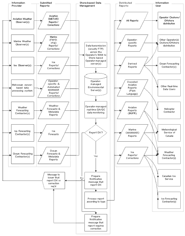
Figure 3-1 depicts the flow of information to and from an Installation, and to information users for real-time data. There are a number of general points to be made in reference to this figure:
- There should be a single distribution channel for any report, from an information provider to an information user. The "single-point-of-failure" approach enables rapid tracing in the event of data disruption.
- Quality assurance and control procedures should be incorporated into all aspects of the reporting process: by the information provider, the information user, and within the data management system.
- Report delivery notification procedures should be a component of routine operations.
- Report correction procedures shall be implemented for all report distributions.
- Users of reports should be able to notify data managers of the disruption of report distribution on a 24-hour per day basis.
- Backup systems are required for the distribution procedures for all critical report.
Figure 3-1 - Real-time Reporting
Click here to view a larger version of this graphic.
3.4.1 Marine Weather Reporting
Marine weather observations will be provided with 24-hours per day coverage. As a minimum, synoptic ship observations will be provided every three hours with special reports as required. The operator should ensure that these reports are transmitted on a timely basis, within twelve (12) minutes of the observation when practical.
Operators are encouraged to use automated systems that will deliver instrument reported weather and / or sea state data to shore on the hour, and every 20 minutes during significantly changing weather and / or sea state conditions.
An operator may elect to report sensor derived (as opposed to manually recorded) data in WMO FM13 international sea station reporting code [16], provided that:
- Automated FM13 format reports are prepared and distributed in real-time to MSC on an hourly basis.
- Wind, temperature, humidity, and sea state sensors are routinely validated according to suitable quality assurance and control procedures.
- If equipment problems occur, bad data should be marked appropriately as missing and an updated Metadata report should be sent.
- There is a capability for manual observations to be taken on a 3 hourly basis should automatic reporting systems fail.
- The marine weather observer has the ability to add fields that are not sensor-derived.
As much sea state and related wind / weather data as possible should be provided in each report. Thus, all code groups should be considered as important. (See Appendix F)
3.4.2 Aviation Reporting
Aviation observations will be prepared by a qualified Aviation Weather Observer, on an hourly basis, on those days when helicopter flights are scheduled. The aviation observation program will be in operation at least during the period 0800 UTC until the last helicopter has landed on shore. It is recommended that aviation reports be issued either daily from 0800 UTC to 1900 UTC or, ideally, on a 24-hour basis. METAR / SPECI codeform is only acceptable for complete aviation weather observations. If the observations are not complete or if there is no SPECI program then an abbreviation of the METAR format (which will not include the word METAR within it) should be used. And, if SPECI are to be included, then it should state what criteria are being used for them.
A capability for performing aviation observing will exist at all times on the Installation. There must be at least two individuals capable of providing sufficient meteorological and helideck-condition information to helicopter pilots to safely land on the Installation at all times.
Aviation reports must be transmitted in METAR or SPECI report, if they are distributed to MSC. Other formats may be used for Operator-specific applications of aviation information. Note that the SAWRS-based aviation observations standard is obsolete and cannot be used.
3.4.3 Metadata Reporting
The Operator should ensure that the metadata described in Appendix E and I are collected. Meteorlogical metadata described in Appendix E will be delivered to MSC at or before the inception of the physical environmental program and in an accurate and timely fashion whenever changes occur.
3.4.4 Oceanographic Data Reporting
Oceanographic Data should be in an ASCII format or a WMO endorsed format; which should include some minimum metadata information (i.e. position, depth, time etc.) Binary data formats are not acceptable. See ICES guidance on formatting.
The Operator should describe its approach in real-time reporting of oceanographic data. The Operator is encouraged to collect real-time oceanographic data whenever possible.
3.4.5 Ice Reporting Procedures
In general, the formatting of ice observations and reports, and the frequency and means of distribution of this information, is left to the Operator, appropriate for their needs, and established in the Ice Management Plan. The exception to this is ice reports that must be provided to CIS, CCG, or IIP. Note that information received (from ships) by CCG is relayed to CIS. CIS and IIP share any information they receive. CIS routinely forward observations to CCG for marine navigation. Therefore, outside of Operator Ice Management Plan reporting procedures, including any reporting to the Regulator, reports to CIS should suffice.
Iceberg information should be forwarded to CIS in MANICE [3] ICE and ICEBERG formats, whenever possible. The essential requirement is timely ice reporting with as much detail as possible. Information received by CIS is coded into ICE and ICEBERG formats (if not already) as a precursor to input to their modelling and operations. Simple worded message formats should be used for any reports to CCG and IIP.
Relevant ice observation, reconnaissance, monitoring, and deflection reports must be provided to the Regulator in the event that ice enters the Installation's ice alert/response zones or in the event that the Operator undertakes an aerial reconnaissance for their area of interest.
Ice information should also be coded in the synoptic ship report and reported according to the marine weather reporting schedule.
The MANICE [3] Iceberg Message Code (ICEBERG) accommodates message header, reconnaissance track, individual, cluster, grid and zone observations, and ship location details.
Note that the reporting of no ice occurrence is valuable in itself. During ice season, vessels should report to the Installation Ice Observer any ice observed or explicitly the non-occurrence of ice. As well, the Ice Observer as part of his/her reporting should also note the absence of ice.
3.4.5.1 Timing
Supply vessels and aircraft, should report ice information (occurrence and non-occurrence) as part of their regular duties (e.g. at the end of a transit leg) as well as during specific reconnaissance assignments. As a minimum, this information should be conveyed to the ice observer on the installation. The vessel may elect to report observations to CCG or IIP.
For an Ice Observer on the Installation, during ice season, the exact timing and frequency of ice observing will be defined in the Ice Management Plan; however, as a minimum, a radar and visual ice watch should be maintained on a regular basis (several times per hour) especially with known ice in the area.
3.5 Equipment Requirements
Weather and sea state monitoring equipment should be “fit-for-purpose”. This section describes equipment selection, installation and functional specifications.
3.5.1 Selection and Installation of Monitoring Equipment
Selection and installation of meteorological and sea state monitoring equipment is the responsibility of the Operator. Minimum accuracy specifications for equipment are provided in Appendix C.
Operators in a particular area are encouraged to pool their resources and to consult with the Regulator with a view to conducting combined measurement programs.
The MSC Port Meteorological Officer (PMO), or other qualified individual, should be consulted for information on the siting of meteorological sensors. The WMO [15] provides guidance for the siting of meteorological instruments.
The Operator should have the meteorological and oceanographic instrumentation at each offshore installation inspected by the MSC Port Meteorological Officer or a qualified independent third party before the installation commences its drilling or production program and the report submitted to the Regulator. Plans for ongoing inspections of this instrumentation should be detailed in the Quality Assurance Program described in Section 5.0.
3.5.2 Instruments
A variety of instruments and techniques may be used to satisfy the objectives of these PEGs. In addition, environmental conditions and site-specific requirements may vary from region to region, and measurement programs should be tailored for the particular geographic area of operation.
These PEGs do not specify the types of instrumentation that should be used by an Operator, but rather identify minimum standards with which the measurements should comply. Measurement programs should be described in sufficient detail and sufficiently far in advance to permit the Regulator to evaluate the suitability of the proposal to the exploration or development program under consideration.
An Operator intending to work in ice-infested or ice-covered waters, where conventional instrument deployment is difficult or impossible should consider the use of bottom-founded or remote sensing instrumentation.
The Operator is responsible to notify CCG of any and all instrument deployments and provide all relevant details as applicable including: nature and description of deployment, latitude, longitude, depths of sub-surface instruments, flasher duration (surface markers shall be outfitted with radar reflectors and a flasher). This information will be used by CCG to notify other mariners of the location of the instrumentation
3.5.3 Monitoring Equipment Specifications
Functional specifications and related considerations for monitoring equipment are provided in Appendix C. The Operator should complete and retain the equipment datasheet in Appendix D for each piece of monitoring equipment.
3.5.4 Integrated Reporting Equipment
Data integration systems, software and hardware, are used frequently offshore to manage and display data from meteorological and oceanographic sensors. It is the responsibility of the Operator to ensure, and be prepared to demonstrate, that all software calculations performed by meteorological and oceanographic data integration systems used in aviation weather and marine weather and sea state reports are correct.
3.5.5 Equipment Approval Process
Appendix G lists instruments that have been used on Frontier Lands in the past. It is not an approved list of equipment and the Operator is not restricted to use of this equipment. In the event that equipment has not been used in the offshore before, it is the responsibility of the Operator to demonstrate that meteorological and oceanographic equipment meets the functional specifications described in Appendix C.
3.5.6 New Technologies
New technology instrumentation may be capable of obtaining much more information than is possible using present conventional methods. Operators using this instrumentation therefore are encouraged to acquire and archive data in greater detail and at more frequent time intervals than specified in these PEGs. Diagnostic data also should be archived to permit the evaluation of data quality and integrity.
- Date modified: